Thunderstorms
What are they?
-
Air mass
thunderstorms (ordinary) è
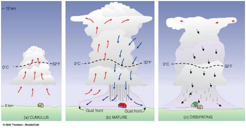
this is a thunderstorm produced by local convection within a
conditionally unstable air mass. Often form in the afternoon when there is maximum
heating at the surface. Rarely reach severe criteria.
o The lifting mechanism for these thunderstorms
is not a frontal boundary but rising thermals off the hot surface.
o Typically last about an hour, because their
updraft and downdraft aren’t separated by vertical wind shear. In other words,
if a thunderstorm doesn’t tilt with height, then the source of the t-storm, the
updraft, will be washed out by the downdraft at the mature stages, killing the
source of the storms upward vertical motion. (More on this in a bit)
o Maximum coverage by rain is only 15-20km in
diameter and the radar looks speckled.
o Usually found in the warm sector and in the tropics.
-
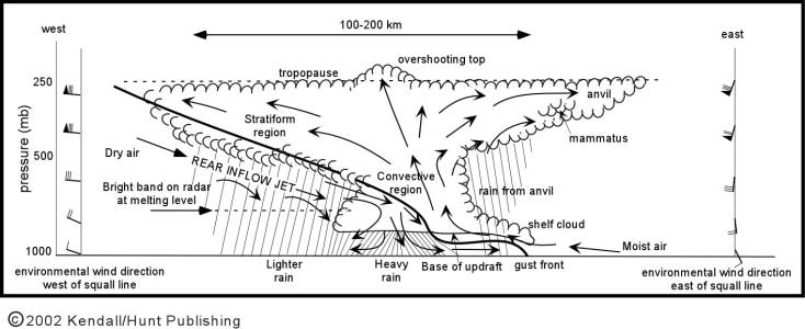
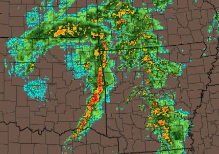
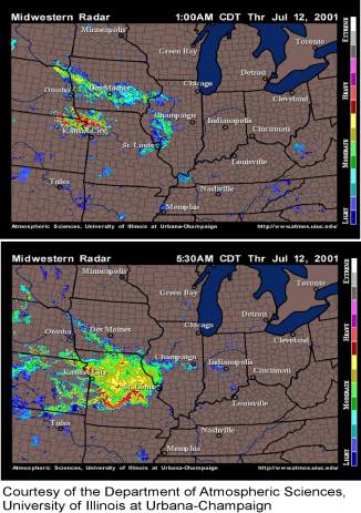
Squall line (or intense thunderstorm with tilted updraft) è
a long line of thunderstorms in which adjacent cells are so close together that
the heavy precipitation from the cells falls in a nearly continuous line.
o Typical lifting mechanism for these
thunderstorms is a cold front or an outflow boundary**
o Can be very long lived lasting several hours
and be severe. Greatest severe threat is damaging winds and hail with the
possibility of a weak to moderate tornado (F0-F2).
o Typically hundreds of kilometers long and look
like an intense band of high reflectivity followed by a region of lighter rain
and lower reflectivity
o These thunderstorms last a long time because
the updraft tilts with height because the winds increase in the vertical. This
separates the updraft from the downdraft and helps move the system along.
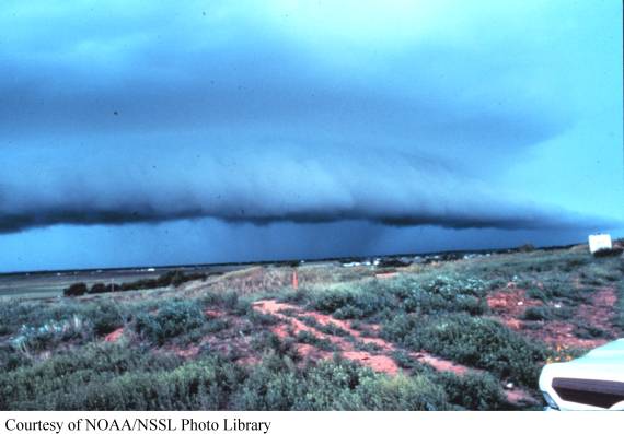
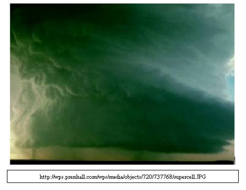
o Besides the lightning, one of the coolest features of the squall line is the gust front (or shelf cloud). The gust front is a non-precipitating cloud that forms out ahead of the squall line due to the outflow from the squall line. Usually it looks very ominous as a dark bowed cloud that scrapes along a few hundred meters above the ground. Usually, when these go over, there is an abrupt temperature and wind change letting you know that the main part of the storm is close by.
-
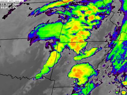
Mesoscale
convective complex è
multi-celled thunderstorms that form in unorganized clusters
o These thunderstorms are not associated with a
frontal boundary
o Last several hours even as long as a day. Can
have severe cells embedded with in the system with high winds and damaging hail
and possibly a weak tornado (F0-F1).
o Form in a conditionally unstable environment
and are often “sparked” by a just a few storms. The outflow of these original
storms acts as a lifting mechanism for other storms to develop
o The MCC can cover an entire state and bring
flooding rains as each successive storm passes over
o On the radar, it looks like a large cluster of individual cells with very high reflectivity. On the satellite image it looks like large blob.
-
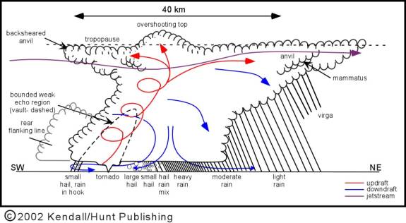
Supercells è
very strong, rotating thunderstorms that are violent http://www.ncsa.uiuc.edu/
o These storms form in unstable regions where
vertical motions are a maximum
o Supercells can last for several hours and leave
a damage path that spans states.
o They form in regions where there is strong
vertical wind shear both in direction and speed
§ This is why the updraft has rotation and why
the updraft is not located over the down draft (as in the ordinary
thunderstorm)
o Severe threats include hail, damaging winds,
lightning and TORNADOES!!
o Form along strong frontal boundaries like dry
lines and cold fronts and often time warm fronts.
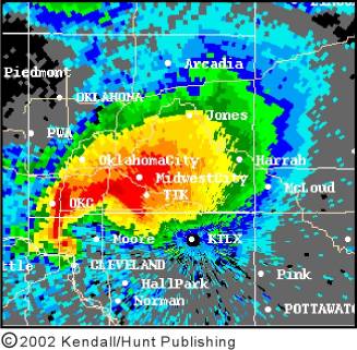
o On the radar they are generally small
(occupying a county or two) but have very high reflectivity. The rotation of
the storm often produces a “hook echo” in the precipitation pattern. In this
hook echo you can also find a tornado.
3 Ingredients
1. Low level moisture source
2. Lifting mechanism
3. Unstable atmosphere
Severe criteria
1. Hail greater ¾ inches in diameter
2. Winds greater then 50kts
3. Tornados
Cool stuff from soundings
that will give you and idea of how severe the weather might be.
1. Lifted index = the lifted index is found from taking the difference of the
actual temperature at 500mb and the parcel temperature at 500mb. It is a tool
used by meteorologists to determine how unstable the atmosphere is. LI = Tenv
- Tparcel
a. The more negative this number is,
the more energy the atmosphere has to produce vertical clouds and therefore
strong updrafts and severe weather
b. Why? Because the more negative that number is
the warmer the parcel is compared to the environment, which is the crux of
stability.
i.
LI>2 No significant activity
ii.
0<LI<2 Showers probable; isolated
thunderstorms possible (if a lifting mechanism is present)
iii.
–2<LI<0 Thunderstorms probable (if a lifting
mechanism is present)
iv.
–4<LI<-2 Severe Thunderstorms possible (if a
lifting mechanism is present)
v.
LI<-4 Severe Thunderstorms probable,
possible tornadoes (if a lifting mechanism is present)
© 2002 Kendal Hall Publishing
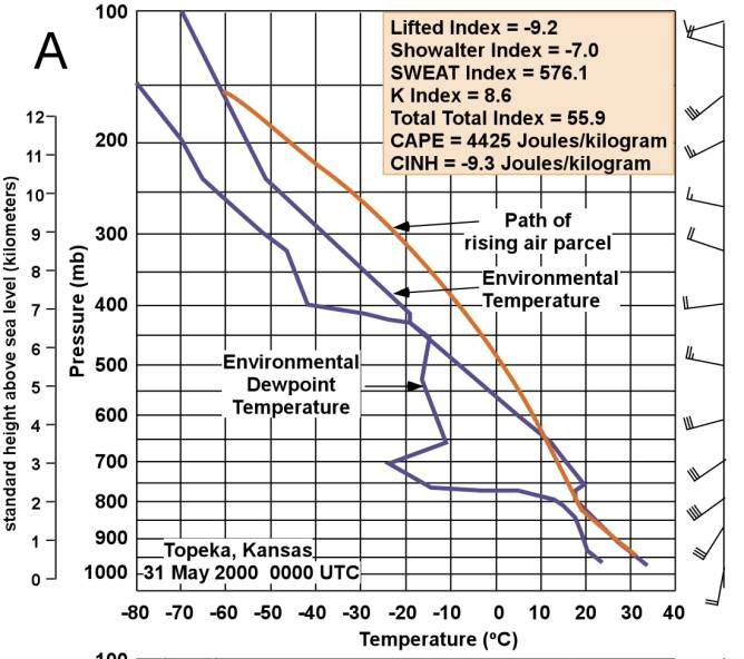
2. CAPE =
convective available potential energy
a. When ever the parcel line is to the right of
the temperature line then there is CAPE and instability
b. The larger the area between the parcel line and
the Temperature line the more CAPE there is
c. The more CAPE there is, the more potential
energy a given thunderstorm has
Today’s Lab
We are going to assess the three ingredients needed for
thunderstorm development!
1.
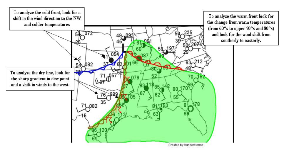
Low level Moisture Source = The best way to find the low-level
moisture source is to contour dew point on a surface map. Places where the dew
point exceeds 50°F (in the winter and
early spring) means that there is a lot of moisture at the surface
2.
Lifting mechanisms = Fronts are the main lifting
mechanisms. So to find this ingredient we look for fronts and analyze them on a
surface map
3. Unstable
atmosphere = The only way to discover if the atmosphere is unstable or not is
to examine soundings. Remember, everywhere that the parcel line is to the right
of the temperature line is unstable. If it is too the right of the temperature
line…then the parcel will always be warmer than the environment and rise on its
own and create vertically developing clouds.